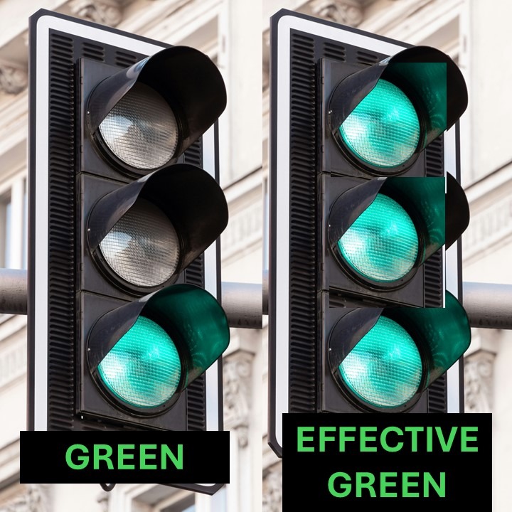
Traffic PCU PCE Converter Calculator
Highway Design, Traffic Engineering, Transportation Planning

What is PCU (Passenger Car Unit) in Traffic Engineering?

When analyzing roads, intersections, and traffic flow, engineers face a common challenge: vehicles are not all the same. A car, a motorcycle, a truck, and a rickshaw each take up different amounts of road space, move at different speeds, and influence congestion differently. To solve this, transportation engineers use the Passenger Car Unit (PCU) — […]

, , , , , , , , ,
Peak Hour Trip Estimation Calculator
Traffic Engineering, Trainings

What is Rush Hour Traffic? How Engineers Calculate Peak Hour Traffic Volumes

When most people talk about rush hour traffic, they’re thinking about the frustrating congestion on roads during the morning and evening commute. Transportation engineers use a more technical term for the same idea: peak hour traffic. Understanding how traffic builds up during these busy times is crucial for designing roads, planning intersections, and evaluating new

, , , , , , , , ,
Traffic Impact Assessment TIA Guidelines
Traffic Engineering, Trainings, Transportation Planning

Traffic Impact Assessment (TIA) Guidelines for Municipalities

Traffic Impact Assessments (TIAs) are critical tools that help municipalities understand how new developments will affect local transportation networks. These TIA guidelines provide a practical framework for preparing and reviewing TIAs in municipalities that do not yet have their own standards. The intent is to balance technical credibility with simplicity, ensuring municipalities can review studies

, , , , , , , , , , , ,
How to estimate transit ridership
Public Transit, Transportation Planning

How to estimate ridership for a transit line — a practical, end-to-end guide

Estimating ridership is the single most important early exercise in mass transit planning. A realistic ridership estimate tells you whether a scheme is worth designing, what level of service you should provide, and whether further investment in full demand modelling is warranted. This guide explains how to estimate ridership using both simple, defensible methods and

, , , , , , , , , , , , , ,
What is AADT
Highway Design, Pavement, Traffic Engineering, Transportation Planning

What is AADT (Annual Average Daily Traffic) in Traffic Engineering?

Annual Average Daily Traffic (AADT) is one of the most fundamental measures in traffic engineering and transportation planning. It represents the average number of vehicles that travel on a roadway segment each day over the course of an entire year. Put simply, it is a way to smooth out traffic variations across weekdays, weekends, and

, , , , , , , , ,
k factor
Traffic Engineering, Trainings

Understanding the K-Factor in Traffic Engineering

In traffic engineering, the K-factor is a critical parameter used in roadway design and traffic analysis. It represents the proportion of Annual Average Daily Traffic (AADT) that occurs during the design hour, and it allows engineers to size and evaluate roadways for their most critical operating conditions. Trying to calculate a traffic signal warrant? Try

, , , , , , , , , , ,
Climate-Resilient Public Transit
Public Transit, Transportation & Climate Resilience

Climate-Resilient Public Transit: Protecting Buses, Rail, and Depots from Extreme Weather

Why Public Transit Needs Climate Resilience Public transit systems—buses, metros, trams, and commuter rail—are the lifeblood of urban mobility. As cities grow, they are also frontline services in the fight against climate change. But extreme weather events pose new challenges: flooded bus depots, overheated rail tracks, disrupted power supplies, and stranded passengers. To maintain reliable,

, , , , , , ,
Innovative Road Design Solutions for Climate Resilience
Highway Design, Pavement, Transportation & Climate Resilience, Transportation Planning

Innovative Road Design Solutions for Climate Resilience

Why Roads Must Adapt to a Changing Climate Roads and highways form the backbone of global transport networks. Yet, they are increasingly vulnerable to the impacts of climate change—flooding, extreme heat, erosion, and storm damage. As weather patterns intensify, traditional road designs are no longer sufficient. Engineers and planners must now integrate resilience strategies to

, , , , , , , ,
Adapting Road and Rail Networks to Climate Change
Pavement, Public Transit, Transportation & Climate Resilience, Transportation Planning

Adapting Road and Rail Networks to Climate Change & Extreme Weather

Why Climate Resilience Matters Climate change is no longer a distant risk—it is a present-day reality. Rising temperatures, heavier rainfall, stronger storms, and frequent flooding are directly affecting how transport systems operate. Road and rail networks, designed for “historical” weather conditions, are increasingly vulnerable to climate extremes that disrupt connectivity, raise maintenance costs, and endanger

, , , , , , , , , ,
brt vs lrt vs metro
Public Transit, Transportation Planning

BRT vs. LRT vs. Metro: Choosing the Right Transit Mode for Your City

Urban mobility is at the heart of sustainable city growth. Around the world, cities face the challenge of moving large numbers of people efficiently, affordably, and with minimal environmental impact. Three of the most common mass transit modes considered are Bus Rapid Transit (BRT), Light Rail Transit (LRT), and Metro (Heavy Rail/Underground Rail). Whatever mode

, , , , , , , , , ,
Scroll to Top